Cartographers and Photogrammetrists
Also called: Cartographer, Photogrammetric Technician, Photogrammetrist, Stereo CompilerResearch, study, and prepare maps and other spatial data in digital or graphic form for one or more purposes, such as legal, social, political, educational, and design purposes. May work with Geographic Information Systems (GIS). May design and evaluate algorithms, data structures, and user interfaces for GIS and mapping systems. May collect, analyze, and interpret geographic information provided by geodetic surveys, aerial photographs, and satellite data.
On a phone, press and hold a picture to save it to Photos.
opens your phone's share sheet, where you can save both to Photos
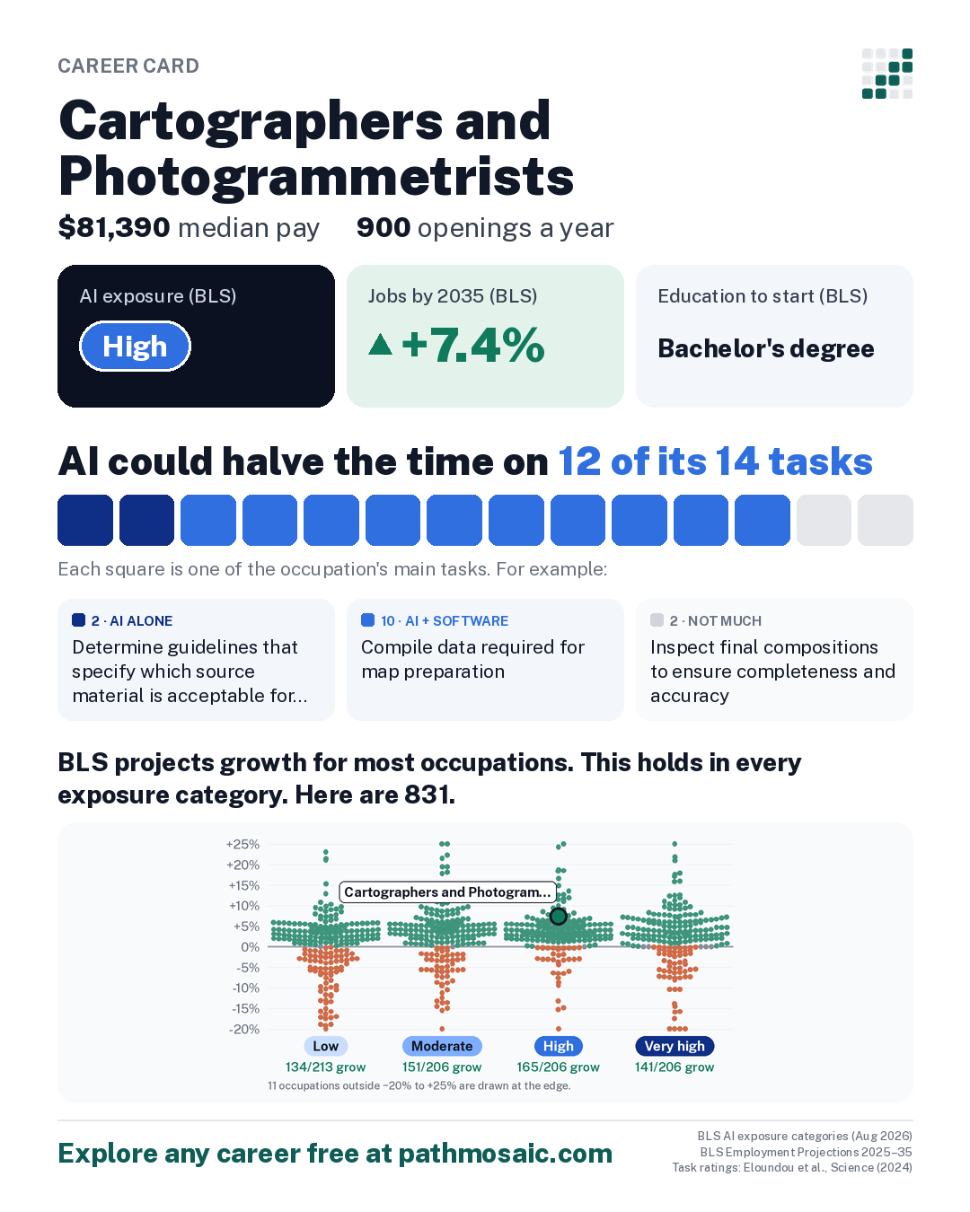
What the data says: AI could halve the time on 12 of its 14 tasks, yet jobs are projected to grow 7.4% by 2035. How to think about this →
About this projection
BLS builds AI into its projections where the research supports it: “BLS generally applies adjustments based on this research conservatively, where there is convincing evidence for a change.”
It also notes a limit: “BLS projection methods are not designed to capture extremely rapid technological change.”
On its AI exposure groups, BLS says exposure “does not imply job loss.”
Recent conditions
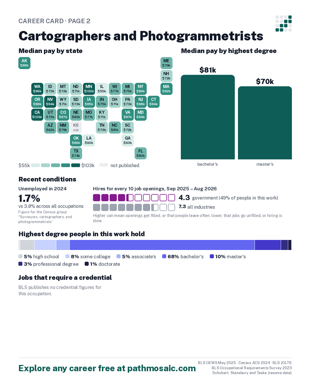
- In 2024, 1.7% of people in this work were unemployed, against 3.8% across all occupations Census ACS 2024, all workers in the Census group “Surveyors, cartographers, and photogrammetrists”
- From Sep 2025 to Aug 2026, 4.3 hires for every 10 job openings in government, which employs about 49% of people in this work, against 7.3 across all industries BLS JOLTS
One box per opening, filled for each hire; hires beyond the openings are added in a lighter shade. Higher can mean openings get filled, or that people leave often; lower, that jobs go unfilled, or hiring is slow.4.3 this industry7.3 all industries
Median pay by state BLS OEWS May 2025, state estimates
Tap a state for its figures.
Median pay in every state
| State | Median | Middle half earn | Jobs |
|---|---|---|---|
| Alaska | $89,170 | $73,990 to $107,560 | 60 |
| Arizona | $82,260 | $68,620 to $96,360 | 400 |
| California | $102,780 | $75,370 to $131,470 | 1,450 |
| Colorado | $86,960 | $78,330 to $104,790 | 1,220 |
| Connecticut | $84,100 | $70,610 to $100,310 | 150 |
| Florida | $79,650 | $64,930 to $94,990 | 610 |
| Georgia | $62,630 | $51,760 to $78,050 | 490 |
| Idaho | $72,930 | $63,360 to $79,440 | 100 |
| Illinois | $54,680 | $48,620 to $84,240 | 180 |
| Indiana | $74,800 | $51,810 to $88,490 | 40 |
| Iowa | $84,570 | $67,910 to $96,960 | 90 |
| Kansas | not published | not published | 230 |
| Kentucky | $71,470 | $56,340 to $83,890 | 90 |
| Louisiana | $59,990 | $58,600 to $76,960 | not published |
| Maine | $78,670 | $65,280 to $86,910 | 40 |
| Maryland | $84,360 | $67,450 to $116,600 | 450 |
| Massachusetts | $92,230 | $81,480 to $107,930 | 160 |
| Michigan | $75,090 | $65,510 to $82,600 | 250 |
| Minnesota | $99,850 | $86,240 to $115,930 | 100 |
| Missouri | $76,950 | $65,000 to $100,420 | 170 |
| Montana | $72,220 | $60,340 to $81,190 | 160 |
| Nebraska | $81,500 | $52,450 to $96,560 | 50 |
| Nevada | $93,560 | $78,170 to $103,570 | 180 |
| New Hampshire | $72,130 | $60,780 to $87,770 | 70 |
| New Jersey | $88,480 | $68,700 to $105,930 | 170 |
| New Mexico | $79,200 | $62,710 to $96,480 | 70 |
| New York | $89,290 | $68,990 to $115,480 | 230 |
| North Carolina | $81,080 | $72,190 to $81,200 | 900 |
| North Dakota | $71,070 | $57,050 to $87,410 | 80 |
| Ohio | $70,990 | $58,460 to $83,170 | 490 |
| Oklahoma | $86,410 | $69,660 to $104,130 | 70 |
| Oregon | $88,240 | $75,850 to $106,600 | 640 |
| Pennsylvania | $73,180 | $65,080 to $81,180 | 140 |
| South Carolina | $72,260 | $57,110 to $92,340 | 150 |
| South Dakota | $72,910 | $49,860 to $93,430 | 140 |
| Tennessee | $72,990 | $63,370 to $86,940 | 150 |
| Texas | $73,970 | $59,280 to $106,570 | 1,780 |
| Utah | $75,220 | $52,730 to $97,470 | 150 |
| Virginia | $86,660 | $70,930 to $97,880 | 860 |
| Washington | $96,100 | $77,790 to $109,980 | 870 |
| Wisconsin | $76,760 | $63,910 to $88,560 | 260 |
| Wyoming | $70,590 | $64,030 to $81,200 | 100 |
Nationally: $81,390. Shades run from the lowest state median to the highest; a territory below that range takes the lightest. How to read this
How AI touches the work
What AI could speed up, task by task, and where people already use it.
AI could halve the time on 12 of its 14 tasks
| AI rating | Its main tasks | Share of Claude conversations May 2026 |
|---|---|---|
| AI + software | Compile data required for map preparation, including aerial photographs, survey notes, records, reports, and original maps. | Not published |
| AI + software | Revise existing maps and charts, making all necessary corrections and adjustments. | under 0.01% |
| Not much | Inspect final compositions to ensure completeness and accuracy. | Not published |
| AI + software | Delineate aerial photographic detail, such as control points, hydrography, topography, and cultural features, using precision stereoplotting apparatus or drafting instruments. | Not published |
| AI + software | Prepare and alter trace maps, charts, tables, detailed drawings, and three-dimensional optical models of terrain using stereoscopic plotting and computer graphics equipment. | Not published |
| AI + software | Build and update digital databases. | 0.01% |
See all 14 tasks
| AI + software | Examine and analyze data from ground surveys, reports, aerial photographs, and satellite images to prepare topographic maps, aerial-photograph mosaics, and related charts. | under 0.01% |
| AI + software | Collect information about specific features of the Earth, using aerial photography and other digital remote sensing techniques. | Not published |
| AI + software | Determine map content and layout, as well as production specifications such as scale, size, projection, and colors, and direct production to ensure that specifications are followed. | under 0.01% |
| AI + software | Study legal records to establish boundaries of local, national, and international properties. | Not published |
| Not much | Identify, scale, and orient geodetic points, elevations, and other planimetric or topographic features, applying standard mathematical formulas. | Not published |
| AI alone | Determine guidelines that specify which source material is acceptable for use. | under 0.01% |
| AI alone | Select aerial photographic and remote sensing techniques and plotting equipment needed to meet required standards of accuracy. | Not published |
| AI + software | Travel over photographed areas to observe, identify, record, and verify all relevant features. | Not published |
Ordered by how important O*NET's respondents rate each task (1 to 5) times the share who say it is part of their job. The ordering is ours. 5 of the 14 have a published share of Claude conversations; “not published” means too few conversations for Anthropic to publish a figure.
Where people already use AI
The tasks above say what AI could speed up. This shows what people are using it for. Its 14 tasks fall under 9 work activities that many occupations share, and Microsoft counted how often each one came up in 200,000 conversations with its Copilot assistant in 2024.
- #13 Operate computer systems or computerized equipment
- #14 Create visual designs or displays
- #37 Determine operational methods or procedures
- and 2 more, in the table below
| Work activity | This occupation's tasks under it | People asked AI for help in 10,000 conversations |
AI did it for them in 10,000 conversations |
|---|---|---|---|
| Create visual designs or displays | |||
| Assess characteristics of land or property | |||
| Gather data about operational or development activities | |||
| Operate computer systems or computerized equipment | |||
| Determine operational methods or procedures | |||
| Select materials or equipment for operations or projects | |||
| Develop technical specifications for products or operations | |||
| Inspect completed work or finished products |
Show all 9 activities
| Analyze environmental or geospatial data |
How people in this work use Claude
What people in this work made with Claude % of conversations
- An analysis or summary14%
- A document or report13%
- Configuration or infrastructure8%
- An explanation or answer6%
- A script or snippet5%
How they worked with Claude
72% of these conversations were about work. Anthropic Economic Index, May 2026.
How to read this
Work activities come from O*NET, which links every task to the broader activities it involves. Microsoft's figures are for the activity across everyone who used Copilot, not for cartographers and photogrammetrists specifically. Copilot is a general chat assistant; dedicated coding tools are not included, so programming help is under-counted here. Activities are listed by how many of this occupation's tasks fall under them.
The task ratings say whether AI could halve the time a task takes: on its own (“AI alone”), or with software built on it (“AI + software”). They were made by people in 2023 (Eloundou et al.). Claude's share is the task's share of all Claude.ai conversations in May 2026; Anthropic doesn't publish a task with too few conversations. None of these add up to the BLS exposure group, which combines five research measures.
More in the Guide: task ratings · task order · work activities · Copilot figures · Claude
High exposure doesn't mean fewer jobs
BLS projects most occupations in its two most exposed groups to grow: 141 of 206 rated Very high and 165 of 206 rated High. Each dot is one of the 831 occupations BLS rates.
Career moves into and out of this occupation
From moves between occupations found in online resumes, 2002–2016. Career changes only: a first job after school isn't a move.
Where people moved in from
of 357 moves in
- 1 Operations Research Analysts Very high +11.9% 11%
- 2 Accountants and Auditors Very high +5.0% 9%
- 3 Training and Development Specialists Very high +10.8% 8%
- 4 Computer Occupations, All Other (2010 group) an older group BLS has since split; no exposure group today 7%
- 5 Geological and Petroleum Technicians (2010 group) an older group BLS has since split; no exposure group today 5%
Resumes over-represent younger, white-collar job-seekers and moves into management. Schubert, Stansbury and Taska (resume data).
Education and training for the occupation
O*NET survey of workers in this occupation
- 36% postsecondary certificate
- 11% some college
- 11% associate's
- 30% bachelor's
- 1% post-bachelor's certificate
- 11% master's
O*NET 31.0 survey of workers in this occupation · 21 people answered.
Census survey (American Community Survey)
- 1% less than high school
- 5% high school
- 8% some college
- 5% associate's
- 68% bachelor's
- 10% master's
- 3% professional degree
- 1% doctorate
Census ACS 2024, all workers in the Census group “Surveyors, cartographers, and photogrammetrists” · 379 people surveyed.
Why the two can differ
O*NET asks about 20 people in each occupation, which makes its shares uncertain, but it reports the exact occupation and counts certificates. The Census survey reaches thousands, but it groups some occupations together and counts degrees only. More in the Guide
Median pay by highest degree full-time, year-round · Census ACS 2024, all workers in the Census group “Surveyors, cartographers, and photogrammetrists”
5 programs, such as Surveying Engineering, Surveying Technology/Surveying and Signal/Geospatial Intelligence.
See all
- Surveying Engineering
- Surveying Technology/Surveying
- Signal/Geospatial Intelligence
- Geospatial Intelligence
- Geographic Information Science and Cartography
Jobs that require a credential BLS Occupational Requirements Survey 2023
BLS publishes no credential figures for this occupation.
Look up certifications, training and licenses U.S. Department of Labor
- Certification Finder ↗ certifications CareerOneStop lists for this occupation
- Training Finder ↗ schools and programs, nationwide; narrow the place there
- License Finder ↗ licenses by state
- Apprenticeship Finder ↗ DOL lists 2 registered apprenticeships in this occupation (DRAFTER, CARTOGRAPHIC; GEOSPATIAL SPECIALIST). Apprenticeship.gov can't be linked to one occupation, so search for “Cartographers and Photogrammetrists” there.
These open in a new tab and send only the occupation's public code. More in the Guide
BLS AI exposure categories (Aug 2026) · BLS Employment Projections 2025–35 · O*NET 31.0 · Task ratings: Eloundou et al., Science (2024) · Microsoft "Working with AI" v1.1 · Anthropic Economic Index (2026-06-26) · Schubert, Stansbury and Taska · NCES CIP–SOC · Census ACS 2024 · BLS JOLTS
See it online, and explore any career: https://www.pathmosaic.com/card/17-1021.00